Tuesday 31 July 2012

ICELAND: THE MOST PEACEFUL COUNTRY IN THE WORLD IS MOULDED BY THE HARSHEST GEOLOGY

2010 ERUPTION OF EYJAFJALLAJÖKULL

Due to the attention and reception this article has received, I have decided to publish it in English so as to reach a wider audience. Enjoy!


       - Antonio

1. INTRODUCTION

According to the IEP, Iceland is the most peaceful country in the world. The two key factors that are responsible for the increase of peace are a decrease in the probability of violent demonstrations after a singular revolution and subsequent trial of its corrupt leaders, and a reduction in the capacity and sophistication of its military resources.

This is clearly due to an investment in culture decades ago. But to speak about Iceland is to speak about volcanoes, some of them famous because of their prominence in current events and in the loss of millions of euros for airlines, stocks, and shutdowns from a lack of primary resources in certain industries. Some will also remember this country from having been stuck in an airport. Nonetheless, the most famous and transcendent volcano in the history of the world is (besides Krakatoa or Vesuvius) the icelandic volcano Laki, not just because of its force, but because of its capacity to change the course of events in Europe and the entire world.


TEMPERATURES IN THE CENTRE OF GREAT BRITAIN; THE SHADOW OF LAKI (1783) LASTS FOR A DECADE

To speak about volcano Laki is to return to the origins of the French Revolution. In 1783 this Icelandic volcano, situated between Hekla and the Eyjafjallajokull glacier which returned to fame in 2010,  registered a prolonged and intense eruption. It emitted enough ash to devastate all the pastures of Iceland and thus cause the death of cattle and of half the population of Iceland. These ashes covered Europe for months, destroying crops and generating a hunger which spread throughout all of Europe. Death tolls rose dramatically in England and in Spain. In France, the eruption of Laki sparked the revolution. That eruption was one of the most powerful of the Icelandic volcano and it is one of the only ones for which there are historical records. The 2010 and 2011 eruptions resulted in enormous economic losses for airlines as well as the paralization of industries, the traffic of primary resources, and people; more than 8 million people were directly affected. Both eruptions, however, were trivial compared to those of 1783 and 1821-1823.  

THE ICELANDIC VOLCANOES
It has taken a land with one of the most violent geological climates, whose inhabitants are constantly exposed to earthquakes and erupting volcanoes, to reach the position of the most peaceful country in the world. Iceland is situated at the top as the nation that enjoys the greatest levels of peace. It is followed by New Zealand and Japan. Together, these three countries are those whose inhabitants have suffered the harshest geological disasters in recent times. We still remember the japanese earthquake of 2011, and those of Christchurch, New Zealand, as well as the Icelandic eruptions of 2010 and 2011.


ICELAND VOLCANO ERUPTION

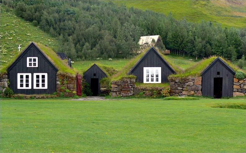
Iceland, the most ancient democracy in the world ( 930 A.C., 500 years before England) is a curious country where one can divert a road or a highway for the sake of not disturbing a community of gnomes or earth spirits or fairies (of the flowers and the gardens), or where an ancient code only allows the cartography of islands and rocks if there are witnesses (seafarers) to at least one seagull's having landed; from this point on these islands or outcroppings can appear on maps, otherwise there would be no guarantee of their firmness and they could disappear. It is a culture that has been physically and psychologically moulded by its geology; a geology that has shaped the way of life of its inhabitant in a way that, to us Southern Europeans, is very difficult to understand. The goodness, generosity, and solidarity of Mother Nature is met in Iceland by its inhabitants with strength, and sudden ruptures of obsolete systems, be these rocks that appear and disappear by volcanic phenomena or economic systems that do not equitably favour a community of more than 300,000 people.

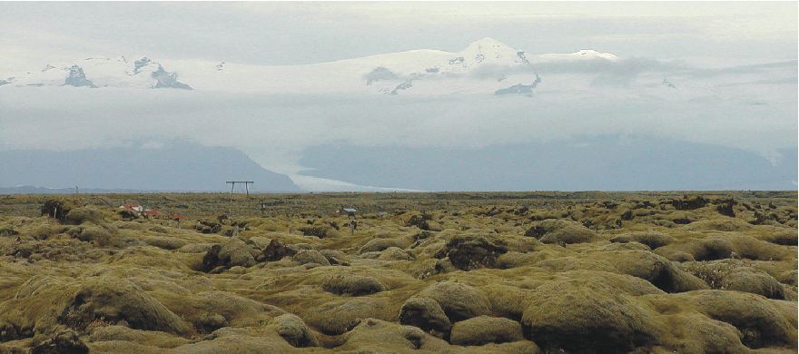
FIELDS OF HARDENED LAVA LEFT BEHIND BY THE ERUPTION OF LAKI IN 1783. BEHIND, THE ÖRAEFAJÖKULL. AT 2109m IT IS CONSIDERED THE MOST ACTIVE AND MOST DANGEROUS IN EUROPE AND ICELAND. IT HAS HAD TWO LARGE AND PROLONGED ERUPTIONS, ONE IN 1362 AND ONE IN 1727.

2. ICELAND, THE COUNTRY WITH THE MOST VIOLENT GEOLOGY IN THE WORLD, CHANGED HISTORY

In 1946, thanks to the invention of sonar, we were able to map out the cartography of the Atlantic Ocean and we observed the existence of a 'scar' that divided the planet from North to South: the mesoatlantic dorsal that separates the North American and Euroasiatic Plates. Twenty million years ago, this dorsal, that shifts and from which magma escapes, collided with an enormous column of rock which rose up and emerged as Iceland.

THE DORSAL: A PLACE TO BREATHE FOR THE EARTH


On top of being broken and divided in two, the island seats itself on an active column 650 km deep. In the same way that this mesodorsal separates America from Europe, Iceland grows at a rate of 2.5cm a year, one side is American and the other European. The Earth has found a place to breathe here.


THE OCEANIC DORSAL SEPARATES ICELAND, GROWING ALMOST 3CM A YEAR.

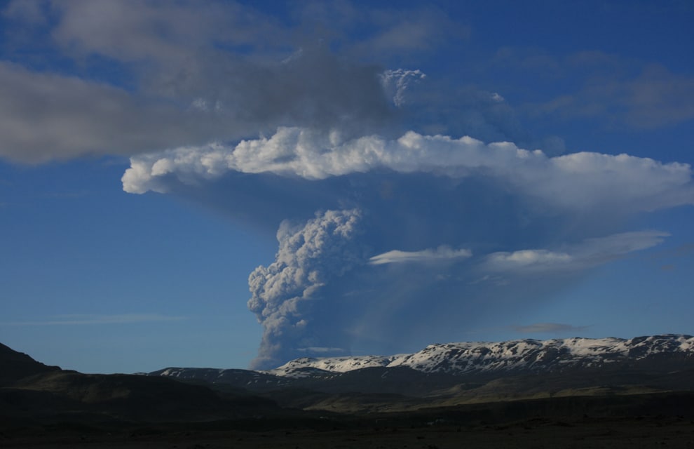
15th OF APRIL 2010: EUROPE BENEATH THE ASHES

Iceland generates a third of the world's lava. We are before the planet's most volcanic island: a latent fumarole which sometimes sends warnings like in 2010 and 2011, but at other times can scare us greatly or create changes in the climate of the world which can also affect the course of human events. It is evident that great changes in nature imply great changes in society, and, moreover, they can repeat themselves: we know that in 1783 the eruption of the volcano Laki seriously affected the world climate for three years.


It is calculated that the 1783 eruption of Laki caused, indirectly, two million deaths. European harvests were scarce: hunger, disease, and speculation with produce gave rise to the French Revolution. It was in fact a geological phenomenon that gave birth to such a change in the social, economic, and cultural expressions of the world, not to mention in human interactions; the beginnings of a modern democracy.

THE FRENCH REVOLUTION. THE LAST CHANGE IN HUMANITY WAS BORN FROM A VOLCANO: LAKI


STROKKUR GEYSER
Laki's ashes covered Europe and destroyed harvests. The resultant famine shot up mortality rates in large swaths of continental Europe; the kingdoms of England and Spain were the most affected. But it was in the kingdom of France where the effects of Laki's eruption ignited the revolution.

This eruption was one of the strongest in modernity and it is one of the few which left historical records with scientific observations about its immediate effects. Years after the eruption, European soils were unable to bear a single fruit.

The ashes razed the first harvests and the volcanic gases provoked months of acid rain that destroyed many years' accumulation of crops. Fungi and other infestations plagued fruit trees and domestic animals. Farmers watched as their animals perished, victims of strange diseases provoked, among other things, directly or indirectly by the fluorine and sulphur that contaminated everything.

While the French people died of hunger, shrewd speculators grew rich on the black market with the shortage of food, many of them linked to the court. The anger of the French people was so great that it resulted in the beheading of their King, Louis XVI, and in the French Revolution. The rest, equality, fraternity, liberty, Enlightenment, and Republic, are history.


Iceland appears to be an inexhaustible geological source of geological and social events; even today it is a volcano of democratic revolutionary impulses. The recent eruption of two of Iceland's volcanoes and the associated paralysis of European air space for two consecutive years has coincided with a constitutional transformation and an example against economic speculation that strangely has not received the attention it deserves. The people of Iceland have taught us a great lesson: gambling with homes, food, and with the economy of citizens for the purposes of getting rich while impoverishing or ruining countries can have clear criminal implications.

Eyjafjallajökull is a stratovolcano formed around 700,000 years ago and it precedes any Icelander, no matter how clever he may think himself. It has been very active, experiencing eruptions around 550, in 1612, between 1821 and 1823, and in 2010, a year which marks a radical change in the establishment of a new Icelandic Constitution. When a people sees itself so small and vulnerable before the mighty force of Nature, economic speculation and enrichment at the cost of impoverishing an entire country lose all the sense they could seem to have when everything is going well.

THEIR INHABITANTS ARE CLEAR: DON'T GAMBLE WITH THE FUTURE

In the eruptions of 1821-1823 two volcanoes were active and erupting at the same time. This is possibly not the first time that this happens. These facts suggest to some vulcanologists that these systems are "mechanically" linked via the Earth's interior. The volcano erupted again the 20th of March, 2010, around midnight, after a 4.5 magnitude earthquake with other less intense earthquakes that announced this one. It erupted again a couple of days later, the 14th of April.

A SEIMIC MAP OF EUROPE
 ICELAND IS THE MOST SEISMICALLY ACTIVE NORTHERN COUNTRY

The chaos this caused in European airspace resulted in the loss of millions of euros for airline companies. That day there began a new eruption, some distance away, this time in the largest crater, just in the centre of the glacier, which caused the melting of the glacier and the consequent flooding of nearby rivers, provoking the evacuation of thousands of people. Water and fire allied in a powerful explosion. At that time the parallel social changes to so much geological activity were already taking shape in a more pacific form. Iceland was the subject of news for two reasons: because of the violence of its soil, and because of the peacefulness of its citizens in denouncing those responsible in the financial crash that left them bankrupt. 


EYJAFJALLAJÖKULL ERUPTING WITH AURORA BOREALIS

This eruption, with both water and fire was explosive; it is estimated that it was between 10 and 20 times superior to the previous eruption of the volcano Fimmvörðuháls.

This second eruption hurled volcanic ash into the atmosphere where it reached an altitude of several kilometres and dispersed itself over an area of thousands of square kilometres causing the interruption of air traffic in the Northeast of Europe.

The 15th of April of 2010, airports close and the airspace over the largest part of North and Central Europe is silent. More than 100,000 flights were cancelled. More than 8 million people were affected.


EL GRIMSVÖTN ERUPTING IN MAY 2011

Almost a year later, the icelandic volcano Grimsvötn flung its ashes into European airspace in May of 2011 and caused the suspension of hundreds of flights, though the crisis was much less severe than in 2010. The European Organization for the Safety of Air Navigation, EUROCONTROL, revised its regulations for ashes in 2010, en 2011 it foresaw that the ash cloud would disperse earlier and its predictions rang true.


The European Comission highlighted that the new European regulations about volcanic ash had minimized problems in comparison with the crisis of May 2010. We had learned something: how to manage volcanic crises in Europe. 


3. ICELAND: THE MOST PEACEFUL COUNTRY IN THE WORLD CHANGES HISTORY AGAIN

IMAGINE PEACE TOWER, REYKJAVIC, ICELAND COMMEMORATING THE 67TH BIRTHDAY OF JOHN LENNON

In the last four years, since the financial crisis sank the most peaceful country in the world into abject poverty, they Icelandic people rose up to organize themselves along those particular parameters that are so linked to their explosive geology: the Government refused to assume the monumental debt of the three most important banks. It nationalized the banks, guaranteed the savings of its citizens and left at the lurch those foreigners, mostly British and Dutch, who had money in these banks. They refused to inject money and they left the banks to be the victims of their own greed. Moreover, dozens of cases of corruption of bank directors came to light and charges were eventually laid against conservative Geir Haarde, who had been the prime minister from 2006 to 2009 and who became the first head of state in the world to be put to the sidelines because of the financial crash and his disastrous management.

Haarde, accused of negligence for not having taken any measures against the imminent disaster, could be sentenced to two years in jail: he is accused of ignoring warnings and for not having done anything to curtail banks who had made themselves rich to the point that they were worth more than nine times the gross national product of the country and who had at the same time made wealthy various politicians and investors in a scandalous way, and who had thus sunken into poverty one of the most educated countries on the planet.

THE FIRSTS PROTESTS IN REYKJAVIK AGAINST THE GOVERNMENT
At the end of 2008, the effects of the crisis in the Icelandic economy are devastating. In October Landsbanki, the most important bank in Iceland, is nationalized. The British Government freezes all its IceSave subsidiary, with 300,000 British clients and 910 millions of euros invested by local administrations and public entities in the United Kingdom. Landsbanki will be followed by the two other largest banks. Their principal clients are in the United Kingdom and The Netherlands, clients whose governments have to reimburse with 3700 million euros of public money.

The currency collapses and the stock market suspends its activity after a 76% dive. The country is bankrupt. The government officially requests aid from the International Monetary Fund (IMF) who approves a 2100 million dollar loan, complemented by another 2500 million from other Nordic Countries. Protests against the Government escalate. General elections are held from which emerges a coalition Government formed by the Social-Democratic Alliance and the Movement of the Green Left, headed by the new prime minister Jóhanna Sigurðardóttir.

EVERY DAY AGAINST THE GOVERNMENT

Via a law amply discussed in parliament a law is proposed to repay the great debt to Great Britain and The Netherlands with a payment of 3500 million euros, a sum that all Icelandic families will pay monthly during the next 15 years at 5.5% interest. The populace once more takes to the streets and demands the law be subjected to a referendum. In January of 2010 the president, Ólafur Ragnar Grímsson, refuses to ratify the law and announces that there will be a referendum.

In March the referendum is held and the resounding "NO" to the payment of the debt is given the force of 93% of votes. The Icelandic revolution thus achieves a new victory in a peaceful way. Since so much justice can not be exported (in case honesty and reason are contagious to the rest of the planet, something which would seriously endanger the interests of investors) in Iceland refugee initiatives are created for all those who want to enjoy freedom of expression; this surprising part of Icelandic history has practically no coverage in any world media.

But Icelanders put their focus on helping those for whom the dissemination of this revolution is an obstacle and for whom, in their countries, it is not possible to put into effect similar initiatives or protests, because of the interests of precisely those people who brought Iceland to ruin. The Icelandic Modern Media Initiative includes, among other things, protection to persecuted online content as the website falls under Icelandic sovereignty.

POT-BANGING, EGG-THROWING, THESE ARE THE WEAPONS THAT BROUGHT DOWN THE CORRUPT BANKS

The IMF, pressured by the United Kingdom and the Netherlands, as well as other countries that invested on Icelandic soil, freezes the economic aid to Iceland in the hopes that the repayment of the loan will be resolved. At this point the government has already begun an investigation into the responsibility for the crisis. The arrests begin: various bankers and top executives are detained. Interpol declares an order of international arrest for the now millionaire ex-president of Kaupthing, Sigurdur Einarsson. 

THE GULLFOSS CASCADE

In this context of crisis, an assembly is elected to draw up a new constitution which takes into account the lessons learned from the crisis and which will substitute the actual constitution which had been inspired by the Danish one. In drawing this up, the soverign educated populace is directly consulted. Twenty-five citizens without any political affiliation are selected from the 522 who presented themselves as candidates, for which it was only necessary to be a legal adult and to have the support of 30 citizens. The constitutional assembly began its work in February of 2011 and presented a charter built on the recommendations agreed upon in various assemblies that were held throughout the entire country.


THE BEST PART OF LIVING ON A LAND OF FIRE

Up until this point everything seemed ideal, however structural problems lay in wait that halted these advanced initiatives from the Icelandic people. The European Union sided with greed and denied Iceland entry until their debts were paid. Nonetheless, in the third trimester of 2010 the country begins to grow again, reaching 1.2% and showing the world that the state is in much better health without the need to rescue banks. By 2012 this figure will quadruple.


The Icelandic economy has begun to recover from the crisis, at the end of last year it returned to the international financial market and recuperated its note for Fitch investments in February. Fitch justified its decision as a reflection of the progress made to restore macroeconomic stability by taking into effect structural reforms and reconstructing the solvency of the sovereign debt. Iceland grew in 2011 to 3%.

The collapse of the value of the Icelandic króna made its exports more competitive. Also, in 2009, the new government kept going into debt and spending for a year until they started to make cutbacks. This contrasts with the case of the Eurozone countries that have problems with their public accounts, that, by having the Euro, are not able to devalue their money and have thus been doomed to harsh cutbacks and austerity measures when requesting aid from the IMF and the EU. Recently, the Fitch risk score agency lowered its mark for 5 european countries, among them Spain and Italy. Standards & Poor did the same with nine, including France. 

Icelandic prosecutors affirm that the government has a duty: to intervene in order to impede that banks become too large to be rescued in the event of a crisis, charging their debt upon their contributors. Top executives of the Kaupthing Bank were accused last month of fraud and manipulation. We other European countries don’t learn.

ICELAND IN A MINUTE


Other initiatives must be approved by the existing government and by the one that will emerge from the legislative elections, and there are other things to highlight from the revolutionary measures taken by the Icelandic parliament: the Icelandic Modern Media Initiative, the star project of the law that attempts to create a judicial framework destined towards protection of freedom of expression and information. 

The attempt is to make Iceland a secure refuge for investigative journalism and freedom of information. Where sources, journalists, and internet providers can hold journalistic information that could be prosecuted in other countries, some of which call themselves democratic. This still living initiative has already been attacked by organized groups reluctant to be investigated in a way that could bring to light their misdeeds. 

Haarde, prime minister from 2006 to 2009, is now 61 and is accused of having acted with negligence, violating the law of responsibility to the ministers, and of ignoring the warning signs that he received of an imminent collapse of the banks, crimes for which he may be condemned to two years in jail. Ultimately Haarde was found innocent, as predicted, but the feeling of rage against the crisis and the banks is still present. Otherwise, had he been found guilty, and sentenced to two years in jail, it would suggest that only one politician was responsible for a worldwide crisis. Haarde insisted that he'd been acquitted on the most serious charges that deal most directly with the origins and handling of the crisis. He characterized the lone conviction as relatively inconsequential and "ridiculous."

ICELAND IS NOW A PROSPEROUS NATION THAT WILL TRIPLE ITS GROWTH IN 2012  


Iceland had already begun its path by asking for entry into the European Commission. The restrictions are many and the interests on both sides are many as well. Again we have David versus Goliath. If their new leaders are more astute than ours, they will not enter into this investors’ club, where homes, food, and health care have already become financial objects. 

But we human beings don’t live in financial objects, but in homes, we don’t eat stock market indices, but bread, rice, fish, no matter how much the food industry wants to optimize profits with the complicity of our enslaved governments, at the cost of our health. Before we Europeans end up living in a financial object or eating ratings, why not consider joining Iceland? It would be better without a doubt. 

According to the Institute for Economics and Peace, the two key factors in the increase of peace in Iceland were the decrease in the probability of violent protests and a reduction in the capacity and sophistication of the military. Iceland occupies the top spot in the world. In Europe, behind Iceland are Denmark, Austria and Finland. Some credit must be given to their respective investments into culture, it’s clear.

Nonetheless, the world at large did not become more peaceful throughout 2011. The world peace indicators again decreased for the third straight year. The conflicts of today are no longer wars between countries, now they are conflicts between citizens and their own governments and in the future this will only increase if the speculative rule persists, if our basic needs are continually turned into merchandise. An increase in the risk of terrorism as well as the problems in the Middle East, Northern Africa, and some European zones have provoked dramatic changes in the Global Peace ranking in which Iceland sits alone at the top.

GLOBAL PEACE INDEX: ICELAND, THE MOST PEACEFUL COUNTRY IN THE WORLD


DISCOVER ICELAND


Monday 30 July 2012

WHY WAS IT SO DAMAGING? THE LORCA EARTHQUAKE, 2011 MAY 11th


Antonio Aretxabala, Cristina Sanz 

Building Department, School of Architecture, University of Navarre
University Campus, 31080 Pamplona, Navarra, Spain

Departure by Blüchel & Von Deylen on Grooveshark
MUSIC BY CHRISTOPHER VON DEYLEN (SCHILLER), DEPARTURE (BI POLAR)


PRESENTED IN THE 2011 WORLD CONFERENCE ON CIVIL ENGINEERINIG AND URBAN PLANNING (WCEUP 2011) IN HANGZHOU, CHINA


The recent earthquake of 11th May 2011 that struck the town of Lorca in the region of Murcia, at the Southeast (SE) of the Iberian Peninsula has been the one with the most destructive effects in the last sixty years in Spain. Its unpredictable and devastating effects: nine victims and direct losses of 1.650.000.000 €. The monumental architectural heritage of Lorca has been severely damaged, with a restoration estimated cost above 50.000.000 €. As one of the heads of the Culture Department of the local government declared: “This seism has been the most important negative impact in European Heritage since the one that partially collapsed the Basilica of Asissi, in Italy, in 1997”.

The accelerations measured in the first event and in the second one, two hours later, were 0,24g (Mw 4,4) and 0,41g (Mw 5,2). The seismic resistant structural code in force, NCSE 02, determines a basic acceleration of 0,12g for the area. The activity of the Alhama-Murcia Fault (FAM), on which the epicentre was located, NE from town centre, at a depth of 2 km and a distance of 10 km. FAM is known since 1979. The amplifying effect of the ground under Lorca, exceeding the previsions of the ground coefficient C established in the code, was one of the causes of the severe damage in built environment. 

These events provide an unsurpassable opportunity to study and analyze, among other areas, the role that microzoning urban planning and design can play in effectively mitigating hazard in the urban areas of the seismic-prone regions, where historical cities with significant heritage are sited. Planners provided of tectonic seismic local maps and detailed information of the sub-surface geology, will make the right decisions in order to preserve not only lives but also the built existing environment and new buildings in future developments. Besides the evident revision of NCSE 02, other building standards should be revised to guarantee the maintenance and retrofitting of buildings not meeting the requirement of seismic resistant design and codes, outstanding the need to include heritage. 

Keywords— Earthquakes, Faults, Heritage Damages, Seismic-Resistant Structural Codes, Urban Planning in Seismic Zones.


I. INTRODUCTION

Spanish professionals concerning the building sector, are not still aware of the fact: Spain is a seismic country. The NCSE 02 needs urgent revision: nine people died in Lorca, none of them due to structural collapses. Geotechnical matters such as the influence of local ground amplification should be reconsidered. Buildings with reinforced concrete (RC) structures but with set-backs, short columns, ground soft story, or incorrectly anchoraged of the non structural elements, are examples of existing architectural configurations non suitable for a correct seismic behaviour. 

Damages on the rich heritage of medieval and baroque buildings in Lorca, evidence the need of specific inspections to determine their structural vulnerability, as well as the implementation of new reinforcement technologies. Special urban planning for those historical centre towns close to active faults is also required, but not only in Spain. Actions are to be taken in order to prevent similar effects in historical places with the same tectonical situation: such as Granada, Córdoba, Murcia, Alicante, Torrevieja, which are potentially laying on the same risks: active faults closer, on grounds capable to doubling or even tripling seismic waves. The earthquake of the Italian town l’Aquila evidenced that other European areas have the same risks. 

On the other hand, people in Europe and specially Spain are not prepared or trained for an adequate behaviour during seismic events, as they are in Japan, California or South America. 

To apply seismic building codes has not been, is not, and it will never be sufficient. It is necessary to develop and implement a multidimensional and interdisciplinary approach, but also a transdisciplinary one to develop a new approach, adequate tools, processes and mechanisms to reduce the seismic vulnerability in European cities situated close to active faults, with the participation of geologists, city planners, engineers, architects, constructors, stakeholders and any other agents regarding the urban planning and building process. Active participation of city officials, decision makers and population is also required. 

II. LOSSES COSTS: 1.650 million €

The Lorca earthquake happened two months after a much stronger earthquake, 8.9 in magnitude, with a destructive tsunami, that struck Fukushima. Japan will have to pay in damages more than 300.000 million USD. This is without taking into account the nuclear crisis, the paralysation of the Japanese industry, the energy supply disruption and the abrupt decrease in exports. The cost to be paid in Lorca has been estimated in more than 1.650 millions €, forcing the president of the regional government of Murcia to claim from the European Commission to determine as fast as possible the amount of financial aid to receive from the European Solidarity Fund. The aid from the local, regional and national Spanish administration, will cover 50% of the costs. The effects of l’Aquila earthquake, with 309 victims, have been estimated in a loss cost of 3.000 million €. The number of victims in Lorca was not higher because the population was warned by a first 4,4 event two hours before the strongest 5,2 second one. Advice was given on radio, TV, and Internet for the people to remain in the streets and open spaces, certainly saving a lot of lives.

III. THE PLACE: LORCA, SPAIN

Lorca is a town in the valley of the Guadalentín River, in the region of Murcia, SE of the Iberian Peninsula (Figure1). The municipality has an extension of 1.676 km², the second largest in Spain, and is 353 m over the sea level, located at 37º 41' N latitude and 1º 42' W  longitude. It is the third most important town in Murcia, with a population of 92.694 inhabitants (Spanish Statistics National Institute, INE, 2010).

Lorca is very well known not only for its historical and artistic architectural heritage but also for its Holy Week processions. They have been declared of International Touristic Interest and Lorca is fighting for them to be declared a World Heritage festival by the UNESCO. Founded by the Greeks, the Romans called it Eliocroca, a combination of the Greek terms helios (sun) and kratón (government), the reason for which is also called Sun City.

IV. THE EARTHQUAKES, FIGURES AND DATA

Fig. 1  Lorca’s earthquake USGS chart (data and map) and IGN map.


According to the report, drafted by the Geological and Mining Institute (IGME) of the Science and Innovation Ministry, a first seismic event (magnitude 4.4 Mw) took place in Lorca, at 15:05 (GMT), followed by a series of minor events (6 tremors, magnitudes around mbLg 2.5) and a second significant shock (5.2 Mw) at 16:47, that lasted 5 seconds.

Up to 130 minor events (between mbLg 0.4 and 3.9 Mw) were registered up until 17th of May. Epicentres were located close at the NE of Lorca (Figure 1), at a distance of about 2 km, coinciding with the Northern part of the Alhama de Murcia Fault (FAM).

The Fault spreads along the NW border of the Guadalentín Valley, from the periphery of Alcantarilla, in Murcia, to the outskirts of Góñar in Almería, a total length of 85 km.

Accelerations reached in the two main events, registered by the stations of the National Net of Accelerographs of ING in Table I and main events in Murcia in the last year in Table II.


V. THE DAMAGES, HERITAGES AND OTHER BUILDINGS

The earthquake caused 9 victims, dozens of injuried, and more than a 10.000 people to be evacuated; the collapse of a multiple dwelling building in La Viña district and countless damages in the 50% of the existing residential buildings. The number of seriously affected buildings in La Viña was specially high. The summary of the damage inspection and classification of 6.405 RC structure buildings carried out was 4.009 declared habitable, 1.335 slightly damaged, 694 heavily damaged and 329 to be demolished. Two buildings were not inspectioned, as they had to be demolished before. 

TABLES I AND II

Fig. 2    EAE classification table. Rodriguez-Pascua et al. (2011)


Lorca Town Council has implemented a geographical event viewer in its web page, to locate every inspectioned building in the municipality, which has proof to be a very useful tool for stakeholders.

Structural geology techniques were used in the study of the historical building damage included in the IGME Preliminary Field Report.

In the inspection, more than a hundred effects were identified and classified in 33 masonry structural historical buildings, according to what Giner-Robles et al. (2009) and Rodriguez-Pascua et al. (2011) defined as Archaeological Earthquake Effects (EAE), depending on whether they are direct or indirect effects (Fig. 2).

After analyzing the global damage extent, the provisional budget was 50 millions €. Final figure, according to the Framework Plan for the Lorca’s Cultural Heritage Recovery, drafted in July, is 51.287.076,93 €.

Complete restoration is scheduled to be completed in five years. A too long-term period according to the importance of tourism in Lorca’s economy and quite doubtful to comply with, due to the fact that the required funds are not available for the moment. The summary of the restoration cost of the most significant buildings is the following:


Espolón Tower (XIIIth c.) San Antonio Porch, Saint Clement Hermitage medieval walls of the Castle of Lorca and the National Parador (public-owned luxurious hotels in historical sites), near the existing synagogue. The Castle is a fortress built throughout Xth and xvith centuries, declared Protected Cultural Asset (acronym in Spanish, BIC) in 1931. The Historical Centre of Lorca, including the Castle, was declared Historical-Artistic Ensemble in 1964. Damage in the Espolón Tower shows evidence of the main direction of the horizontal shakes, due to the NE location of the epicentre. The most damaged corners are those in the NE-SW diagonal of the plan (Figures 3 and 4). Final budget: 11.169.293,13 € 

Fig. 3  Espolón Tower, before the earthquake

Fig. 4  Damaged tower top, afterwards. SW corner, first plane

Church of Santiago (XVIIIth c.) Baroque style building, its dome collapsed after the second seismic event, as seen in Figure 5. The Collapse analysis revealed that restoration works carried out in the fifties, reinforcing the masonry structure with too rigid RC elements, did not contribute to reduce the structural vulnerability but even increased it, being the most possible partial collapse cause. The bell tower also shows evidence of damage due to rotation, with main damages in NO-SE facades (Figure 6). Final budget: 2.100.256,00 €. 

Fig. 5  Aerial view of the Church of Santiago, before and after the dome collapse

Fig. 6  Detail of damaged  top of the tower, Church of Santiago 
Church of San Francisco (XVIth c.). Built in the renaissance period, with a beautiful classical main facade and baroque interior, declared BIC, the provisional budget for its restoration in the preliminary report was the only figure significantly minor than the final. (Figure 7)

Final budget: 4.340.771,16 €. 

Santo Domingo Monumental Ensemble, ( XVIIth -XVIIIth c.). Placed in the Main Street of Lorca, comprises the convent or church and the Rosario Chapel (Figure 7). Only three facades of the cloister are still standing (Figure 8). Final budget: 2.727.256,00 €.


Fig. 7  Towers of Santo Domingo, before and after partial demolition
Fig. 8  Santo Domingo’s cloister damage. Detail and general view.

Fig. 9  Inside damage.Convent of the Virgen de Huertas


Collegiate Church of San Patricio (s.XVIth-XVIIth c.). Renaissance interior, baroque facade, declared Historical-Artistic Ensemble in 1941. Final budget: 2.960.000 €. 


Guevara Palace (XVIIth - XVIIIth c.). Also called the Columns House, originally was a luxurious baroque residence, with a noble cloister. Declared BIC in 1984, is one of the most representative buildings of civil architecture in town. Final budget: 1.163.392 €.


Convent of the Virgen de Huertas (XVth c.). Baroque ensemble, rebuilt in the XVIIth century, recently restored (Figures 9 and 10). Final budget: 2.525.000 €.


Fig. 10  Virgen de Huertas. Inside, before the earthquake
Apart from historical buildings and others damaged in the town centre, all of them with masonry load-bearing walls structures, very vulnerable to seismic activity, a high number of buildings in the district of La Viña (with a population of about 4.900 people) were also devastated, although they were, in comparison, recently built, with RC structures. All of the victims were killed in the streets, by falling facades or non-structural construction elements, broken loose from buildings. Parapets fell because of the inertial or shaking horizontal forces on the elements themselves (Figure 20). Portions of outer double-leaves facades, due to the distortions imposed by the RC structure, swaying back and forth, or separation-pounding at the interface between the adjacent structure (Figure 19, building in demolished block, called San Mateo Residence). Other ornamental cantilever elements fell down because they were insufficiently or incorrectly anchoraged or tied to structural elements. 

A three story multi-dwelling building with ordinary moment frame RC structure collapsed after the second shock, because of the incorrect configuration of the basement columns. 

Columns with shorter or variable effective height to that of the other regular ones within the same storey, called short columns, are stiffer, hence have increased seismic demand. They attract higher values of induced horizontal forces during the earthquake than their counterparts, being highly vulnerable. Brittle failure of short columns caused the collapse of the aforementioned building. A scheme of its ordinary moment frame RC configuration is presented in third place in Fig.11.


Fig. 11   Short columns formation: Due to staircase beams or ground level
differences. Scheme of the RC building structure collapsed in Lorca.


Other configurations including short columns, frequent in existing buildings in seismic-prone zones, due to the disposition of staircase landing beams between two floors or variation of columns height with different ground floor levels, are included in first and second place in the same figure.

Different pictures of the collapsed structure in Lorca in Figure 12. Other short column structures did not collapse, Figure 14. 

Heavy masonry walls placed in direct contact with ground floor columns create and artificial short storey, increasing the shear demand in columns accordingly, causing severe damage as seen in Figure 15. The inexistence of sufficient gap between masonry and the columns, restrains their free movement, as explained in Figure 16.


In the case of recent buildings, damages in the RC structures are those to be expected in structures designed to support a peak of acceleration three times smaller than the value registered, undesirable configurations (soft storey in Figure 17), lack of incorrect detailing of steel reinforcement or maintenance of the structure in Figure 18. In older structures, the effects can also be attributed to incorrect seism-resistant design, including columns, joints and others. 

Fig. 12  Views of RC building collapsed


Fig. 13  Devastated ground columns inside a building

Fig. 14  Damaged short column, uncapable of dissipating the amount of energy needed before loosing resistance

Fig.15  Pillars partially confined by the masonry of the facades, forced, though, to behave like short columns 

Fig.16  Scheme of the difference between the theoretic model and the real behaviour, columns of former picture

Fig.17  Irregular and not uniform distribution of masses, stifness, strength and ductility,  combined with inexistance of masonry under first floor spans and different height of pillars (soft story)

Fig.18  Lack of reinforcement or insufficient maintenance
Fig. 19  Fissures and cracks due to the horizontal forces acting in both directions, in unreinforced brick masonry facade


Fig.20  Demolition of the rest of a roof parapet, that partially  fell down into the pavement


VI. THE CODE NCSE02

In Spain, the seismic-resistant design and construction structural code in force is NCSE 02. This is a result of the revision of the former NCSE 94 that substituted the PDS-1/1974. This, in turn, had only been preceded by the first Spanish seismic-resistant standard, dating from 1968, PGS-1. 

That code did not include a seismic risk map, but referred to the one in MV 101, the building loads code in force at that moment. NCSE 02 is based on previous knowledge and includes the analysis of the most relevant earthquakes registered in Spanish history. 

It also applies new criteria and the lessons learnt from the latest destructive earthquakes of Mexico (1985), Armenia (1988), Loma Prieta (1989), Kobe (1995), Izmit (1999) or Taiwan (1999) considering also, the rest of the European (Eurocode 8) and international standards, that have also been revised and renewed recently.


Fig. 21  Compilation of the GSHAP regional seismic hazard map for Europe, Africa and Middle East


Fig. 22  NCSE 02 seismic risk map
The NCSE 02 map (Fig. 22) establishes a zonification for the basic acceleration values, the basis to obtain the design seismic acceleration, fundamental data required to design any seismic-resistant structure. The basic acceleration corresponding to Lorca is 0.12g, being Granada and Alicante the zones with the highest values, over, 0.16g. The top is the town of Santa Fe in Granada 0.24g. In spite of that, the latest harmful seismic movements in Spain have been located in the region of Murcia, that suffered five important seisms in the last twelve years: Mula (February, 1999), Bullas (August, 2002) y La Paca (January 29th 2005, magnitude 4.4 Mw, 40 km away from Lorca). And, unfortunately, the last one in Lorca (May, 2011), all of them were related to the FAM.


The seismic design acceleration obtained, multiplying the basic by the rest of parameters included in NCSE 02 (four coefficients: contribution k = 1.00, ground C =1.61, risk r =1.00 and ground amplification, S =1.27) is 0.15g, clearly less than the maximum acceleration registered, 0.41 g. This kind of movement is usual in these circumscriptions, but the facts that the hipocentre was so superficial and the epicentre so close to Lorca were crucial for the disaster. The crust structure in Murcia, like in the rest of the southeast of Spain, is similar to an assembly of domino pieces horizontally laid: when one of them moves, all the others are affected (Figure 23).


VII. THE EXPLANATION: THE GROUND

Lorca is on the axis of the FAM, both seismic movements that 11th of May were very superficial (2 km depth) and the second (5.2 Richter) was only 3 km NE from town centre. 

Fig. 23  Murcia tectonical map
This explains the high number of minor events registered months after the two main events (more than 200), identified across the segments in which the FAM is divided in. This is a transcendental question because similar configurations may exist not only in the region of Murcia but also in many others regions in Europe, such as Navarra, Basque Country, Aragón and Cataluña, in Spain and their counterparts on the north side of Pyrenees, in French Departments, Pyrenéés Atlantiques and Orientaux. 

It is also important to underline the fact that Lorca is a very rich geotechnical site, concerning the soil textures and specimens, underneath Lorca. The Guadalentín River and all its sediments form a cuvette capable of amplifying the seismic waves, as seen. Due to the fact that part of these materials can be qualified as collapsible, the consequences are difficult to foresee. 

The year before the earthquake, the FAM was in an inter-seismic period with no activity at all, thus, it was quite predictable, with obvious limitations, that something was going to happen; some tectonical experts even announced it (Figure 24). The real unexpected issue was not the earthquake itself but the top basic acceleration generated. 

Fig. 24 Scheme and tectonic efforts afecting the Lorca basin 


VIII. CONCLUSIONS


  • Lorca should become an in situ research laboratory for the whole Europe. The earthquake consequences require a much deeper and extensive multidisciplinary analysis, in order to establish the lessons-learnt for seismologists, geologist, engineers, architects and stakeholders. It is too early to have final consistent conclusions, but we are in time to point out a series of striking combined causes. In Spain, we have the first opportunity to apply the content of the NCSE 02 article 1.3.3 after being classified VII, in such an extended area. The content is this: “...after a high intensity seism, an report of every construction located in areas with intensity equal o higher than VII (EMS scale) should be drafted, in order to analyze the consequences of the earthquake on it, as well as to determine the kind of measures to be taken in relationship. The author of the report should be the technical expert responsible for the maintenance, or if there was not one, the proprietor or legal owner of the construction”. 

  • Actions must be taken in order to raise public awareness. It is essential to raise the awareness of the population in general, specially the building sector, regarding the existence of areas highly vulnerable to earthquakes in Spanish geography. The time has come to determine the preventive actions to be adopted as well as to plan all the procedures to follow in case of high magnitude seism’s striking. These two should be the main objectives to be promoted by the administration, as well as to transmit a clear message: Spain is a country with seismicity capable of killing people, seriously damaging buildings, infrastructures or heritage, or even paralyzing the economic activity of a whole region. 

  • Urban planning. Tectonic and/or seismic research should be coordinated with micro-zoning and urban planning development, in order to make the location, volume, number and height of buildings and other of their significant characteristics, consistent with the geological and seismic ground information available. Furthermore, urban development of areas with high seismic risk should require the previous elaboration of local maps, including among other natural risks, the seismic risk. 

  • National Heritage. Spain is the country with the second most important number of National Heritage sites in the world, after Italy and before China. It seems both appropriate and necessary to make an investment in the future of Spain, one of the most important countries in the World regarding cultural tourism and still not developed enough. 

  • Spanish Heritage (historical, artistic, architectural, landscape, gastronomic and so on) should be promoted to the highest post in the scale of priorities, those regions with the most important cultural or historical richness should be provided with special plans related to seismology and heritage preservation. Possibly, one of the most ambitious tasks to assume in future days may be the reinforcement of churches, palaces, convents and castles, like those now painfully damaged in Lorca, as well as to foresee their behaviour during an earthquake, like the one that shook Lorca, on Wednesday, 11th of May. 

  • NCSE 02 has proved to be very effective regarding structural elements, but needs to be revised and completed, in reference to: Constructive non-structural elements, such as, parapets, cornices, installations, partitions and other: there is a lot to do regarding their design, location, anchorage, flexibility, etc. It is also obvious the need of reinforcing masonry walls, either made of bricks of or stone in those places where they are traditionally used.

  • Local seismotectonic zoning, above all in zones where it is well known that seisms of the L’Aquila or Lorca type could happen in the future. 

  • New maps are required, as well as new approaches to the response spectrums from waves generated by shallow or superficial faults activity. It is urgent too, to revise the values of the contribution coefficient k after the experience in Lorca. 

  • Increase on the basic acceleration values of the zones close to active faults, especially in towns in line with the ones already identified with recent activity, and in the future, with those to be discovered. 

  • Major investigation, study and consideration of all the layers of the ground affected by foundations which may receive seismic waves. The code classification in types I, II, III and IV is too vague and undetermined to prevent structural damage due to geotechnical reasons. 

  • Real geotechnical effects should be considered, revising the C coefficient associated to the ground. It is not enough to quote the possibility of liquefaction of granular soils, there is a wide range of deflections not considered in NCSE 02, such as collapses, densifications, reactivation of consolidations, etc., either in soil or in rock. Part of the new text to include as an extension of the in force code should have a geotechnical and geomechanical character according to the effects on buildings and infrastructures. 

  • The appearance of new seismic zones, should also bring about the exigence to adapt, as far as possible, the existing buildings to this new code. The Spanish Technical Building Code (CTE) included two important new concepts: the need to guarantee the safety requirements of structures, not only in the design phase but also during the execution phase, and while the building is being in use. Also, it underlines the requirement of maintaining buildings properly in order to guarantee their performance and behaviour during their useful life. This essential requirement is very important for seismic-resistant structures of existent buildings, that could have been designed complying with former codes. It is absolutely necessary to extend the Technical Buildings Inspection (ITE), already in force in many cities in Spain, to the whole country, with a special emphasis upon those structures in high seism risk areas. That would be the best option to reach our goals. 

A final reflexion to highlight, regarding what Lorca suffered last May or l’Aquila in 2009, once more, is that reconnaissance reports, published shortly after every earthquake strikes contemporary historical cities all around the world, always describe failures in buildings’ configurations identified in codes as non-recommended in seismic zones (11).
And, of course, the people behaviour before, meanwhile and after a seismic event, if correctly trained, will save many lives in Europe


References 

[1] Aretxabala Díez, A. (2006) “Variability of conventional geotechnical tests in collapsible soils”. Soil Engineering num. 8, chapter 6, pp 153-169. ISBN 84-96140-22-9, 2006. 

[2] Martinez Díaz J.J, Hernández Enrile J.L. (1991)“Reactivation of the Alhama de Murcia Fault (Sector of Lorca –Totana): Kinematics and stress-field from the Messinian to the present” Geogaceta. 

[3] Martínez Díaz, J.J.(1999) “Seismotectonics of the FAM. Sismogenteics implications of the Lorca earthquake June 1977”. 

[4] Estudios de Geología, 55 pp 251-266. 

[5] Rodríguez Estrella, T. (2008) “Global Atlas of the Murcia Region. Ed. La Verdad 

[6] Alasset, P.J. and Meghraoui, M. (2005) “Active faulting in the western Pyréneés (France): Paleoseismic evidence for late Holocene ruptures”. Tectonophysics, 409, pp. 39–54. 

[7] Augusti, G., and A. Sinopoli.(1992) ”Modeling the dynamics of large block structures”. Meccanica number 27, pp 1950- 2110 

[8] De Luca G., Marcucci S., Milana G, Sano T.(2005) “Evidence of Low-Frequency Amplification in the City of L’Aquila, Central Italy, through a Multidisciplinary Approach Including Strong- and Weak- Motion Data, Ambient Noise, and Numerical”. Modeling Bulletin of the Seismological Society of America, Volume 95, No. 4, pp. 1469–1481. 

[9] Galli P., Camassi R. (2009) . “Seismic hazard characterization of the city of L’Aquila (Abruzzo, Central Italy): new data from geological, morphotectonic and gravity prospecting analyses”. Studi Geologici Camerti, Volume Speciale, Int. Workshop Camerino, Rome, 21-26 June 2009. pages 7-18. 

[10] Guevara Pérez, T. (2009).“Arquitectura Moderna en zonas sísmicas”.Gustavo Gili, Barcelona.ISBN.978-84-252-2292-4. 

[11] Guevara Pérez, T. et al. (2008) “El efecto de columna corta o columna cautiva”. IDEC, Facultad de Arquitectura y Urbanismo Universidad Central de Venezuela 

[12] Guevara Pérez, T. “El piso blando y el piso débil”. (2009) IX Congreso Venezolano de Sismología e Ingeniería Sísmica, Caracas 19-22 May. 

[13] Guevara T. and García L.E. (2005).“The Captive and Short Column Effects”. Earthquake spectra.The Professional Journal of the Earthquake Engineering Research Institute. Volume 21. 

[14] Kramer, S.L. (1996). “Geotechnical Earthquake Engineering”. Prentice Hall, 653 p. 

[15] Lahuerta J.A, Sanz C. (1995) “Seismic actions in building: NCSE 94”. RE Revista de edificación, No. 21, pp. 43 – 53. 

[16] Michetti, A.M. et al. (2007). “Intensity Scale ESI/2007. Memorie Descriptive Della Carta Geologica D’Italia, 74”. APAT, SystemCart Srl, Roma, Italia. 

[17] Michetti A.M., Esposito E. et al.(2009) “Rapporto sugli effetti del terremoto aquilano del 6 aprile 2009”. RPT03 – 20.04.2009. QUEST INGV 

[18] Michetti A.M. ,Vittori E. et al (2009). “Earthquake ground effects during moderate events: the l’aquila 2009 event case history” 1st INQUA-IGCP 567 InternationalWorkshop on Earthquake Archaeology and Palaeoseismology. 7-13 September 2009 Baelo Claudia (Cádiz, Spain) Abstracts Volume, pp. 87-90. 

[19] Monaco P. et al. (2009). “Geotechnical aspects of the l’Aquila earthquake”.Earthquake Geotechnical Engineering Satellite Conference. XVIIth International Conference on Soil Mechanics & Geotechnical Engineering 2-3 October. Alexandria, Egypt. 

[20] Mörner, N.A.(2004). “Active faults and paleoseismicity in Fennoscandia, especially Sweden: Primary structures and secondary effects”. Tectonophysics No. 380, pages 139-157. 

[21] MV 101-1092. Hosing Ministry. Official State Bulletin (BOE) No.35, 1963/02/09, 19 pages (2207-2225) 

[22] NCSE-94. Civil Works, Transport and Environment Ministry. Official State Bulletin (BOE) No. 33, 1995/02/08, 46 pages (3935- 3980) 

[23] NCSR-02.Fomento Ministry. Official State Bulletin (BOE) No. 244, 2002/10/11, 70 pages. (35898 - 35967) 

[24] Ortuño, M., Queralt, P., Martí, A., Ledo, J., Masana, E., Perea, H., Santanach, P. (2008). “The North Maladeta Fault (Spanish Central Pyrenees) as the Vielha 1923 earthquake seismic source: recent activity revealed by geomorphological and geophysical research”. Tectonophysics, No.45, pp. 246-262. 

[25] Pergalani, F., V. Petrini, A. Pugliese, and T. Sano. (2002). “Seismic microzoning using numerical modelling: the Umbria-Marche earthquake of the 26 September 1997”. Numerical Analysis and Modeling in Geomechanics, J. W. Bull (Editor), Spon Press, London. 

[26] PDS-1 (1974) Part A. Developtment Planning Ministry. Official State Bulletin (BOE) No 279, 21/11/1974, 17 pages (23585-23601) 

[27] PGS-1 (1968) Goverment Presidency. Official State Bulletin (BOE) No. 30, 1969/02/04, 18 pages, (1658 to 1675) 

[28] Rodríguez-Pascua, MA., Perez-Lopez, R., Giner-Robles, J.L., Silva, P.G., Garduno-Monroy, V.H., Reicherter, K.(2011) “Archaeological Effects (EAE) in archaeoseismology: Application to ancient remains of Roman and Mesoamerican cultures”. Quaternary International 242 (1), pp. 20-30. 

[29] Rodríguez Segurado, Montse el al. (2005) “Caracterización de la Respuesta Sísmica de los Suelos. Aplicación a la ciudad de Barcelona”. Universidad ed Barcelona 2005. 

[30] Tsige M.,García Flórez I. “Proposed Geotechnical-amplification classification of geological materials in Murcia”. Departamento Geodinámica, Facultad de Ciencias Geológicas Universidad Complutense de Madrid. Geogaceta 16. 

[31] UNE EN 1998 -1 Eurocode 8. Design of structures for earthquake resistance . Part 1: General rules, seismic actions and rules for buildings. AENOR, 2011-10-13, Génova 6, 28004 Madrid 206 pages 

[32] Wells, D. L. y K.J. Coppersmith, (1994). “New empirical relationships among magnitude, rupture length, rupture area, and surface displacement”. Bulletin of the Seismological Society of America, 84 (4), pp. 974-1002. 

[33] Framework Plan for the Lorca’s Cultural Heritage Recovery http://www.lorca.es/concejaliasyservicios/concejaliasyservicios.asp?id=1547

[34] Lorca seism information IGN.http://www.ign.es/ign/layout/sismo.do

[35] Geological preliminary field report of the lorca earthquake (5.2 Mw, 11th may 2011) IGME. http://www.igme.es/internet/default.asp

[36] Global Seismic Hazard Assesment Programme (GSHAP) reginal seismic hazard map for Europe, Africa and Middle East. http://www.seismo.ethz.ch/static/GSHAP/